
Peakify mountain weather app: every feature
Peakify is a mountain app for hillwalkers, fell runners and wild campers. Check summit weather, follow a GPS route, share your location in an emergency, tick off Munros and Wainwrights, and analyse your Strava and Garmin activities, with widgets for the numbers you check every day.
Mountain weather and maps in the app
Find a hill and check its summit weather before you leave the house.
On the web: Browse UK mountains
-
Explore map
A 3D map of summit pins you can tilt and rotate. Filter by height, distance, saved, bagged or whether a route exists, and add layers for footpaths, routes, popularity and slope steepness.
Why it helps: You see which nearby summits have a route and which ones you have already climbed.
-
Map styles
Switch between satellite, topo, streets and dark maps, or OpenStreetMap, OpenTopoMap and CyclOSM.
Why it helps: Topo and OpenStreetMap styles show footpaths that satellite images hide.
-
Mountain list
Browse mountains by country, nearest first or highest first.
-
Favourite mountains
Save the hills you climb most. Your favourites feed your widgets, dark sky rankings and cloud inversion alerts. Free accounts keep two favourites.
Why it helps: Your regular hills show up on your Home Screen and in your alerts.
-
Search
Search mountains, your activities, saved routes and app screens from one box, with your recent searches kept.
Why it helps: Activity and route results come from data already on your phone.
-
Mountain pages
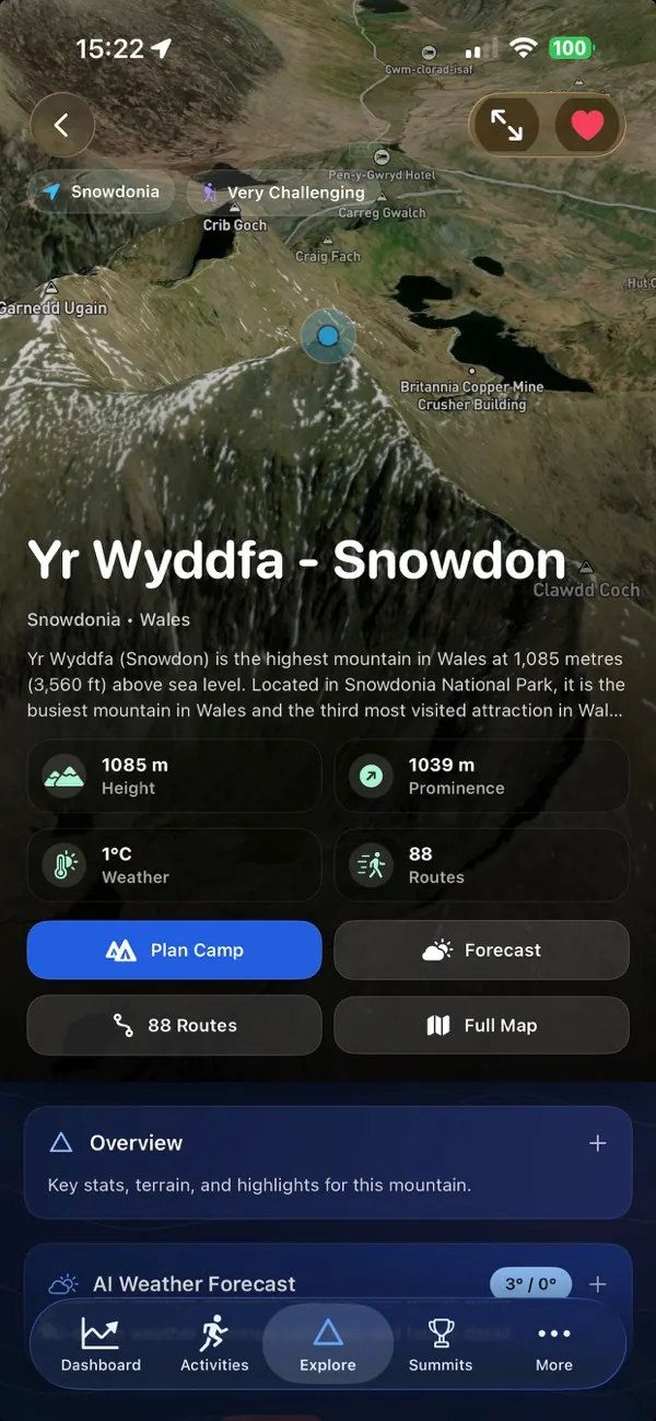
Each mountain has its height, prominence and range, key features, an elevation profile, a 3D map with a 360° summit view, and routes to the top.
-
Summit weather
Current conditions, today's forecast and a 7 and 14-day outlook for the summit: temperature, wind, humidity, pressure and cloud cover.
-
AI weather summary
An AI-written summary of the summit forecast, with daily and hourly detail.
Why it helps: You get the forecast in a few sentences before you open the numbers.
-
AI hiker summary
An AI summary for hikers covering ground conditions, navigation difficulty, estimated time and what to take.
-
Stargazing forecast
Tonight's stargazing score for the mountain with its cloud, light pollution and moon factors, moonrise and moonset, and a 7-day outlook.
-
Sunrise and sunset
Sunrise, sunset and twilight times for the summit. Share the day's summary with your group.
-
Snowfall
The latest snowfall and snow depth on the mountain.
Mountain Briefing: summit forecasts
A full forecast for one mountain, laid out to help you decide whether to go and when.
-
Verdict
One sentence at the top gives the best weather window, or tells you there isn't one. The card takes the colour of the day's worst conditions.
Why it helps: You can read it in a second, even standing in wind and rain.
-
Summit, mid and base
Conditions at three heights on the mountain, with the cloud base and freezing level set against the summit.
Why it helps: You know whether the top will sit in cloud or below freezing.
-
Here and now
Your phone's live compass heading and GPS altitude next to the forecast, including how far you are below the summit. It switches on when you are near the hill.
Why it helps: It ties the forecast to the spot you are standing on.
-
Which face
A wind rose names the most sheltered face hour by hour and shows which slopes recent wind and snow have loaded. Peakify works this out from the weather history and labels it as no substitute for an avalanche forecast.
Why it helps: You can pick the side of the hill out of the wind.
-
Avalanche bulletin
Where an official avalanche service covers the mountain, the briefing shows its bulletin word for word: the danger level out of 5, the affected aspects and a link to the issuer, such as SAIS.
Why it helps: You read the official bulletin next to the weather, with its source.
-
15-minute nowcast
A strip of 15-minute steps for the next two hours, wherever the chosen model publishes them.
Why it helps: You can decide whether to set off now or wait out a shower.
-
Hours ahead and graphs
An hourly table comparing summit and base, plus up to 7 days of graphs you can scrub through: wind at height, pressure, freezing level, temperature, rain, cloud, visibility, thunderstorm risk, sun and UV.
-
Forecast model picker
Choose the weather model behind the briefing: ECMWF, the ECMWF AI model, ICON-EU, ICON-D2, AROME, the UK Met Office 2 km model, MET Norway, GFS, HRRR or an automatic blend. Peakify hides models that don't cover the mountain.
Why it helps: In the UK you can use the Met Office's 2 km model, which shows hills in more detail than global models.
-
Model agreement
A grid of weather models against hours, coloured by severity, with a line saying where they agree and where they differ.
Why it helps: You see how far to trust the forecast before you commit to a day.
-
Cloud inversion tile
When an inversion is likely, the briefing tells you the summit may be above the cloud and links to the full inversion forecast.
-
Share the briefing
Send the briefing as WhatsApp-ready text or as an image card with a link back to Peakify.
Why it helps: Your group chat gets the whole forecast in one message.
-
Bright light mode
One tap switches the briefing to bold dark text on white.
Why it helps: You can read it in direct sun.
-
Offline briefing
With no signal, the briefing keeps the last forecast on screen and tells you when Peakify fetched it.
Why it helps: You still have a forecast when signal drops on the hill.
-
Recent and nearby
The briefing start page lists your recent briefings and the mountains nearest to you.
Sunrise, cloud inversions, dark skies and snow
Plan around sunrise, cloud inversions, dark skies and snow.
On the web: Cloud inversion forecast · Dark sky events · Snowdar snow forecast
-
Sun and Moon planner
Drag through the day on a 3D map to see where the sun and moon rise and set from any spot. Peakify uses the real skyline from terrain data. Save plans for later.
Why it helps: You get the moment light clears the ridge in front of you, which can be minutes after the official sunrise.
-
Sun and Moon reminders
A saved plan can remind you the day before and an hour before your planned time.
-
Cloud inversion forecast
Peakify ranks mountains by their chance of a cloud inversion over the next 7 days, with a list or map, country and score filters, and the reasons behind each score.
Why it helps: You know which morning and which summit give you the best chance of standing above the clouds.
-
Cloud inversion alerts
An evening alert when one of your favourite mountains scores 70% or more for the next morning.
Why it helps: You can set an early alarm the night before instead of checking each morning.
-
Snowdar
Peakify ranks peaks by first expected snow and total snowfall over the next 14 days, with snow depth, rain and a snow and rain radar map.
Why it helps: You see where snow will fall first and where it will last.
-
Dark sky events
A calendar of meteor showers, eclipses and moon phases with tonight's sky. Each event has its own page with viewing times and safety notes, such as eclipse eye safety.
-
Event reminders and calendar
Tap Remind me for alerts the evening before and shortly before an event, add it to your calendar, or share it.
-
Where to watch
For each event night, Peakify ranks your favourite mountains by dark sky score.
Why it helps: You know which of your hills will have the clearest, darkest sky that night.
Hiking routes and GPS navigation
Plan a route, check it, then follow it on the hill.
-
Route planner
Pick one or more summits in order and a start point, or use your location. Peakify snaps the route to mapped walking paths. You can draw waypoints by hand, compare alternatives or import a GPX file.
Why it helps: You get a route that follows real paths in a few taps.
-
Saved routes
Keep your routes private. Edit them, reverse them to walk end to start, or start navigation.
-
GPX export and download
ProExport your saved routes and download mountain routes as GPX files.
Why it helps: You can load the route onto your watch or into another mapping app.
-
Open GPX files
Peakify opens .gpx files from other apps, and the route planner can import them.
-
Offline route packs
Download a route's path, waypoints and turn instructions to your phone. Peakify warns you when a pack is out of date. Map tiles still need a connection.
Why it helps: Turn instructions and off-route warnings keep working without signal.
-
Route preflight
Before you start, a checklist covers the offline pack, your direction of travel and live tracking.
-
Route navigation
GPS navigation on the map with the next instruction, progress, distance and ascent remaining, your ETA, altitude, time to sunset and off-route alerts.
Why it helps: Peakify warns you when you leave the route.
-
AR route ribbon
An optional camera view draws your route as a ribbon over what you see. Peakify labels it as a guide to check against the map.
-
Navigation Live Activity
Your progress, distance left, ETA, time to sunset, next direction and a route map on the Lock Screen and in the Dynamic Island.
Why it helps: You can follow the route without unlocking your phone.
Hill safety and emergency SOS
Tools for when the day doesn't go to plan.
-
Mountain plan
During navigation Peakify builds your personal ETA, a turnaround time, a cloud window and a safety briefing for the route. You can share the plan.
Why it helps: You set a time to turn back before you need one.
-
Live tracking link
Start navigation and Peakify can create a peakify.ai link that family and friends open to follow you.
Why it helps: People at home can see where you are while you are out.
-
Emergency SOS
Shows your OS grid reference and GPS coordinates and writes a rescue message you can copy or send by SMS or WhatsApp. It reminds you to call 999 or 112 and ask for the police, then mountain rescue, explains the UK 999 text service, and shows your GPS accuracy, battery, altitude trend and remaining daylight.
Why it helps: You can give rescuers your exact location in the format they use.
-
SOS live location
Create a tracking link that sends your location. You can stop it or make a new one at any time.
-
Avalanche risk map
A map of official avalanche bulletins by region, plus a Peakify conditions index worked out from weather and terrain. Peakify labels the index as unofficial.
Wild camping
Plan a night out and stay in touch at camp.
-
Camp planner
Link a camp trip to a mountain, drop a pin for your pitch, and set dates and notes. Peakify reminds you 3 days before, the evening before and the morning of the trip, each time with a forecast briefing.
Why it helps: You get the latest forecast at the moments you decide whether to go.
-
Camp Chat
Group chat over Bluetooth and local Wi-Fi, with nearby rooms, private rooms you join by code, photos, videos and pinned notices. Phones pass messages on to each other.
Why it helps: Your group can talk at camp with no phone signal.
Summit bagging and challenges
Peakify logs every summit you reach from your GPS activities.
On the web: Summit challenges · Bagged summits map
-
Automatic summit detection
Peakify matches your GPS tracks from Strava, Garmin and Apple Health against nearby peaks. You choose how close your track must pass for a summit to count.
Why it helps: You don't log summits by hand.
-
Summit challenges
48 challenges, including the National, Yorkshire, Welsh and Scottish Three Peaks, the Welsh 3000s, Wainwrights, Munros, Corbetts, Grahams, Hewitts, Nuttalls and Marilyns, the Bob Graham, Paddy Buckley and Ramsay Rounds, and Alpine 4000ers. Each shows your next targets, a timeline and a map.
Why it helps: Peakify ticks summits off from your activities as you climb them.
-
Badges and share images
Finish every summit in a challenge in one activity to earn a badge, and share a challenge image.
-
Bagged summits
A list of every summit you have logged, filterable by name and height. Open one to see the activities and route that prove it.
-
Bagged summits map
A map of the summits you have and haven't bagged in the area you are looking at.
Why it helps: You can spot unclimbed peaks near the ones you know.
-
Report a wrong match
Tell Peakify when a summit or challenge match looks wrong.
-
Elevation progress
Your vertical gain over time, a weekly climbing target, consistency, ramp warnings and readiness guidance.
Running, hiking and race analysis
Analysis of your runs, hikes and rides from Strava, Garmin and Apple Health.
-
Dashboard
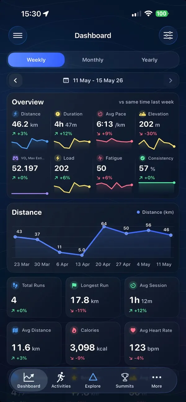
Weekly, monthly and yearly overviews with stats, recent activities and health tiles. Add and reorder sections, choose your main sport, and compare with the same point last period.
-
Activities
Every synced activity, filterable by runs, rides, hikes and workouts, summits only, or run day.
-
Activity analysis
For each activity: route map and elevation profile, summits, heart rate and pace zones, climbs and gradient, VAM, NGP and rTSS, fitness, fatigue and form, recovery cost, terrain, conditions, segment PRs, and Garmin strength sets and reps.
-
AI Coach
A verdict on each activity with a summary, a next step and a suggestion for your next run.
-
3D flyover
Fly along an activity in 3D with a pause at each summit. Hikes open on a turning 3D terrain map.
-
Flyover video editor
Choose a style, length, speed, terrain, clouds, summit highlights and a stats overlay, then export a video in a 9:16 frame for stories.
Why it helps: You can turn a hike into a video for your stories.
-
Route images and video
Save or share a route as a map image, a transparent stats image or a 10-second video, in several layouts.
-
Running Lab
VO2 max trend, predicted race times, an adaptive weekly goal, a workout builder, injury risk flags, grade-adjusted pace, cadence, hill and heart rate drift checks, and segment PR alerts.
-
VO2 max
A running VO2 max estimate with a 12-week trend, a confidence level, your fitness age, how you compare with people of your age and sex, and ways to raise it.
-
Best efforts
Personal bests over standard and ultra distances, times, trails and climbs, with new PBs flagged.
-
Run streaks
Your current, best and previous streaks, a run-day calendar, every route in the streak, and a share image.
-
Strava segments
Search and sort your Strava segments with attempt history, time and speed graphs and trends.
-
Backyard ultra analyser
Peakify finds backyard ultra events in your runs and breaks down each loop: time against the cutoff, rest bank, pace against heart rate, fatigue, survival chance and a loop heatmap.
-
Compare races
Put races or runs head to head: splits, pace against distance, how alike they are, shared Strava segments and a route replay.
-
Create and manage races
Build a race from a GPX route, add checkpoints on the map, save drafts, duplicate races and share a support crew link. Free accounts create two races with up to three checkpoints each.
-
Live race tracking
Start a live session and Peakify uploads your location, even with the phone locked, at a rate that suits the race length. Followers open a public link with your location, pace and ETA at each checkpoint.
Why it helps: Your crew sees where you are without calling you.
Health and recovery
Your Garmin and Apple Health data turned into daily guidance.
-
Health Hub
Sleep, heart, stress, Body Battery, steps, recovery, HRV, breathing, training load, injury risk and cardio fitness on one page.
-
Sleep
Sleep score, stages and timeline, naps, sleep debt, timing, broken sleep and recovery.
-
Illness check
A 7-day illness risk forecast from changes in your health signals.
Why it helps: You can get an early hint before you feel ill and ease off training.
-
Heart and HRV
Resting heart rate, HRV and overnight heart trends, with your HRV compared against your own 28-day normal range.
-
Breathing and blood oxygen
Overnight breathing rate and how stable your blood oxygen stays.
-
Stress and Body Battery
Garmin stress load and Body Battery: charge against drain, when it will run out, and a 30-day trend.
-
Steps
Daily movement and how consistent it is.
-
Recovery
Sleep, heart, stress and training combined into one recovery view.
-
Training load and injury risk
Short and long-term load across everything you sync, and the load, terrain and recovery factors that raise your injury risk.
-
Cardio fitness
Your cardio fitness trend against your own baseline.
iPhone and Lock Screen widgets
Home Screen and Lock Screen widgets for the numbers you check every day. Preview them all in the app's widget gallery.
-
Mountain Briefing widget
Summit, mid and base conditions with the freezing level for a mountain you choose.
-
Mountain weather widgets
ProWeather, wind, rain, snow, visibility, dark sky and inversion details for a favourite mountain, plus a quick look at all your favourites.
-
Dark Sky Tonight
ProTonight's stargazing score, moon phase, cloud cover and the next astronomy event.
-
Daylight
ProSunset time, usable daylight left and when golden hour starts.
Why it helps: You can see at a glance whether you have time for one more top.
-
Next camp trip
ProA countdown to your next camp trip with the weather trend.
-
Summit widgets
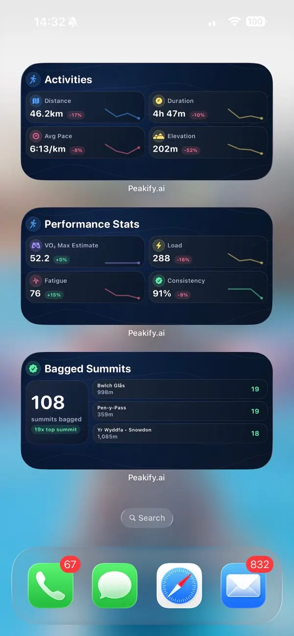
ProYour top bagged summits, your latest summits and progress on a summit challenge.
-
Everest counter and monthly vert
ProThis year's climbing as a number of Everests, and this month's climbing with a projection.
-
Activity widgets
ProRecent activities, your latest route and stats, performance stats, best efforts and PR targets.
-
Running widgets
ProWeekly, monthly and yearly running totals against the last period, your run streak and your VO2 max trend.
-
Training insight widgets
ProToday's verdict in plain words, a workload gauge, your 6-week fitness trend, weekly mileage against the 10% rule, cadence, efficiency, negative splits and fitness age.
-
Recovery readiness
ProA readiness score with fitness, fatigue, form, VO2 max and consistency.
-
Health widgets
ProHealth stats, last night's sleep, a daily health grade, sleep debt with a bedtime target, Body Battery run-out time, illness risk, breathing rate, blood oxygen and weight trend, plus one widget for each Health Hub factor.
-
Lock Screen widgets
ProActivity stats for the week, month or year, a single stat of your choice, a 7-day HRV line against your baseline, and resting heart rate with its trend.
Strava, Garmin and Apple Health
Peakify works with the apps and watches you already use.
-
Strava
Connect Strava to sync activities and summits, with stats by activity type.
Why it helps: New activities arrive in Peakify without you doing anything.
-
Summits in Strava descriptions
Peakify can add the summits you reached to new Strava activity descriptions.
Why it helps: Your Strava followers see which peaks you climbed.
-
Garmin Connect
Connect Garmin to import new activities, health data and your full activity history.
-
Apple Health
Peakify reads your workouts, routes, sleep, heart and wellness data, but doesn't write to it. New workouts sync in the background.
Why it helps: New workouts arrive without opening the app.
-
Activity alerts
Optional notifications for new activities, new summits and finished Garmin imports.
Account and settings
Set Peakify up the way you use it.
-
Sign in with Apple or as a guest
Sign in with Apple, or look around as a guest first.
-
Units
Metric or imperial. Peakify follows your phone's region until you choose.
-
Appearance
Light, dark or match your phone.
-
Customisable dock
Choose two of the shortcuts in the bottom bar, from Activities, Summits, Briefing, Sun and Moon, Inversion, Snowdar, Dark Sky, Avalanche, Health, Widgets or Connections.
-
Main sport
Pick running, hiking, cycling, walking, swimming, strength or multi-sport to set your dashboard.
-
Tracking frequency
Choose how often live tracking sends your location.
Why it helps: A lower rate saves battery on long days.
-
Your account
Report a bug, log out, or delete your account and all its data from the app.
Peakify Pro
A monthly or yearly subscription that unlocks the extras.
-
All widgets
ProEvery Home Screen and Lock Screen widget. The Mountain Briefing widget is free for everyone.
-
GPX export
ProExport saved routes and download mountain routes as GPX files.
-
No limits
ProUnlimited favourite mountains, races and checkpoints.
-
No ads
ProPro removes the banner ads.
Questions about the Peakify app
Is the Peakify app free?
Yes. You can download Peakify and use its mountain weather forecasts, maps, route planning, navigation and safety tools for free. Peakify Pro is a monthly or yearly subscription that adds every widget, GPX export, unlimited favourites, races and checkpoints, and removes the ads.
Does Peakify work without phone signal?
Partly. Download an offline route pack and your turn instructions and off-route warnings keep working. The Mountain Briefing keeps the last forecast it fetched, and Camp Chat runs over Bluetooth and local Wi-Fi. Map tiles need a connection.
Which weather models does the Mountain Briefing use?
You choose. The briefing offers ECMWF, the ECMWF AI model, ICON-EU, ICON-D2, AROME, the UK Met Office 2 km model, MET Norway, GFS, HRRR or an automatic blend, and hides any model that doesn't cover the mountain.
Does Peakify work with Strava, Garmin and Apple Health?
Yes. Connect any of them and Peakify imports your activities, finds the summits you reached and builds your training and health analysis. Apple Health workouts sync in the background.
Which summit challenges can I track?
48 challenges, including the Three Peaks, the Welsh 3000s, Wainwrights, Munros, Corbetts, Grahams, Hewitts, Nuttalls, Marilyns, the Bob Graham, Paddy Buckley and Ramsay Rounds, and the Alpine 4000ers.
What does the emergency SOS screen do?
It shows your OS grid reference and GPS coordinates, writes a rescue message you can send by SMS or WhatsApp, reminds you to call 999 or 112 and ask for the police, then mountain rescue, and can share a live location link.
More about the app: hill bagging app · hiking app · cloud inversion app
Get Peakify on your iPhone
Forecasts, routes and training in your pocket.